*Latest update August 21st, 2020*
Background on Complaint
Recently I have been going through documents sent to me by various police departments. The documents I was sent by the Westfield Police Department concerned me so I filed a written complaint. Below are my sources of information, and the responses I was sent. This page will be updated as more information comes in.
Local BLM Protest:
On June 4th, 2020, A peaceful local Black Lives Matter protest was held at Park Square from roughly 4pm – 8pm. Count set by MassLive at over 500 people in the area.
The Westfield Police Department Drone Policy: I was sent this Policy, dated November 2019 which has certain protections for protests written into it. As a drone cannot be flown without collecting data – I read this as a No Fly Restriction.
VI. Civil Rights and Civil Liberties Protections
UAS-recorded data will not be collected, disseminated or retained solely for the purpose of monitoring activities protected by the U.S. Constitution, such as the First Amendment’s protections of religion, speech, press, assembly, and redress of grievances (e.g., protests, demonstrations).
It also has a section which states the public should be notified except in a few situations. As far as I know as a citizen of Westfield, this has never happened.
Except for those instances where officer safety or investigation could be jeopardize and where reasonably possible and practical, agencies should consider notifying the public
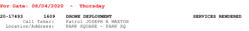
Westfield Police Flight Log: Proves a drone was launched by Westfield Police during the June 4th Protest, at 16:09, breaking the above Civil Rights Policy
FAA Law Enforcement Brochure – mentions the part 107 restrictions that must be obeyed if they are not COA. *Update See COA Below**
Based off of this information, I felt obligated to submit my complaint to City Hall and the Police Chief, along with a followup FOIA for more information.
Westfield Police Public Records Request for Drone Flight Path at BLM Protest
Westfield’s Response to above public records request:
The files: (All in one ZIP)
Online Copies: (Reload individual document or the whole page if you are experiencing issues with this, or download the file pack above)
 Loading…
**NOTE** To display these following drone files online, I needed to convert them from KMZ, which the original FOIA request contained, to KML format. If you would like to view the original files, please download them and view in google earth.
Download Above Flight DJIFlightRecord_2020-06-04_[15-01-04].kmz
Download Above Flight DJIFlightRecord_2020-06-04_[15-41-27].kmz
Download Above Flight DJIFlightRecord_2020-06-04_[16-33-44].kmz
Download Above Flight DJIFlightRecord_2020-06-04_[17-07-12].kmz
Westfield Police Public Records Request for COA
Loading…
My Thoughts on Westfield Police Violations
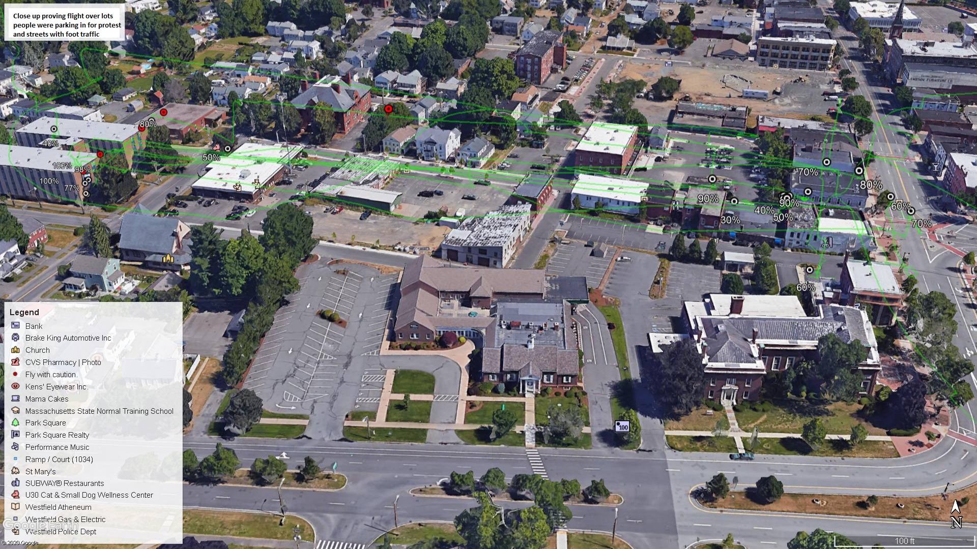
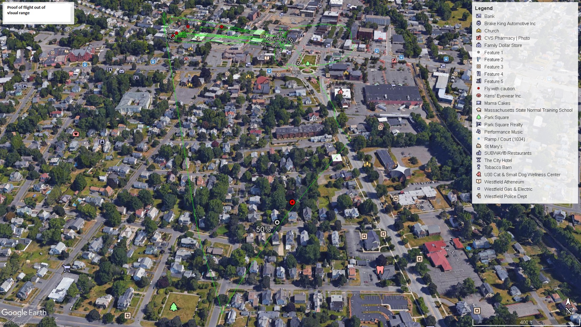
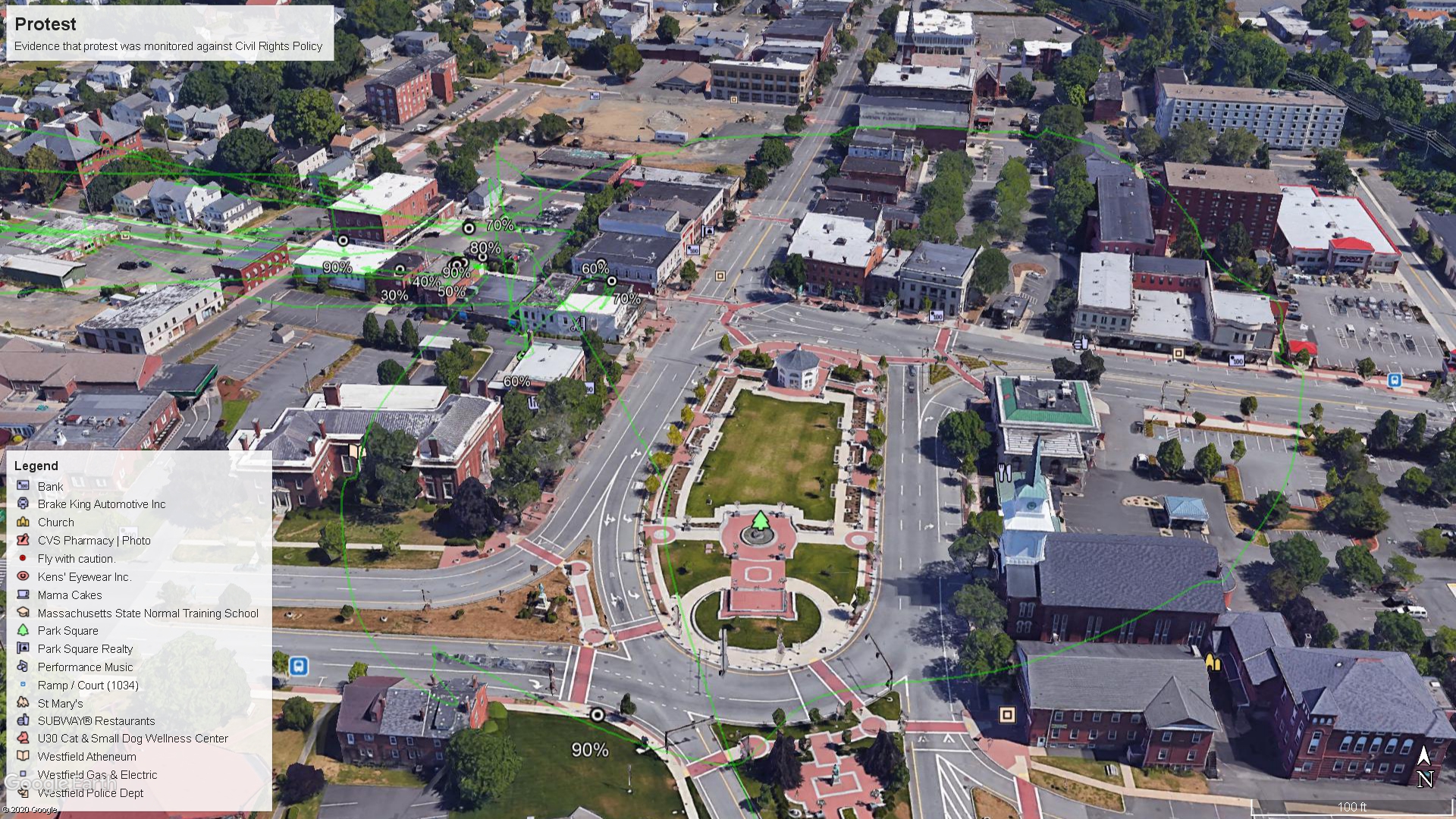
I have taken above KMZ files and extracted some static image captures with Google Earth.
The below image shows the flight path over areas where over 500 people would have been parking, walking and driving at the Westfield June 4th Protest. This is against FAA 91.119a part of Westfield Police COA which was not waived. This states you may not fly anywhere below an altitude that if power was lost would not cause undue harm to persons or property. This is also against 107.19/39.
FAA 91.119b States over congested areas, 1000ft above the highest point is the lowest altitude they can fly. Their COA also says no flights over humans, unless its necessary to safeguard human life. This would be a hard sell to me as every news source lists this as peaceful, and there were many other surveillance methods already in place on Park Square that would not have required putting so many people at risk by even being in surrounding areas.
Below is my submission for evidence of a flight outside of visual range. This is against FAA Part 107.31 and 107.33. This is also against the Westfield Police COA, both by visual range and same “undue hazard” risk above.
According to historic weather on that day (and confirmed in newspaper pictures) skys were mostly cloudy further reducing visibility. This is further impacted if they were flying 1000 feet in the air above highest obstacle.
Regardless of above, Citizens outside of Park Square have an expectation of privacy. A drone should not have been flown over their back yards, recording video.
I end with a visualization of the drone flight path around park square. This is proof that the protest was monitored by Westfield Police. This drone at least video recorded the whole protest, but was audio recorded as well? Was facial recognition done on the processed video files? What other types of technologies did this surveillance drone use on people not suspected of any crime?
If you have issue with any of this information – please make your voice heard to your representatives. Link them to this page, send them the list of demands for privacy reform, etc. Below is a starting point:
- Westfield City Council: https://www.cityofwestfield.org/122/City-Council
- Westfield Police Department: https://westfieldpolice.org
- FAA Bradley FSDO: https://www.faa.gov/about/office_org/field_offices/fsdo/bdl/